


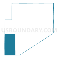
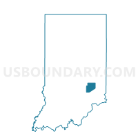
JACKSON TOWNSHIP, Decatur County, Indiana
About
Outline

Summary
| Unique Area Identifier | 576803 |
| Name | JACKSON TOWNSHIP |
| County | Decatur County |
| State | Indiana |
| Area (square miles) | 40.29 |
| Land Area (square miles) | 40.27 |
| Water Area (square miles) | 0.02 |
| % of Land Area | 99.95 |
| % of Water Area | 0.05 |
| Latitude of the Internal Point | 39.19809060 |
| Longtitude of the Internal Point | -85.64107740 |
Maps

Graphs
Select a template below for downloading or customizing gragh for JACKSON TOWNSHIP, Decatur County, Indiana


Neighbors
Neighoring Voting District (by Name) Neighboring Voting District on the Map
- CLAY TOWNSHIP, Decatur County, IN
- CLIFTY 3700, Bartholomew County, IN
- GENEVA 03, Jennings County, IN
- HAWCREEK 4600, Bartholomew County, IN
- ROCKCREEK 5200, Bartholomew County, IN
- SANDCREEK, Jennings County, IN
- SANDCREEK NORTH, Decatur County, IN
- SANDCREEK SOUTH, Decatur County, IN
Top 10 Neighboring County Subdivision (by Population) Neighboring County Subdivision on the Map
- Geneva township, Jennings County, IN (7,584)
- Haw Creek township, Bartholomew County, IN (3,905)
- Sandcreek township, Decatur County, IN (3,120)
- Rock Creek township, Bartholomew County, IN (1,424)
- Clay township, Decatur County, IN (1,287)
- Clifty township, Bartholomew County, IN (1,004)
- Jackson township, Decatur County, IN (988)
- Sand Creek township, Jennings County, IN (872)
Top 10 Neighboring Unified School District (by Population) Neighboring Unified School District on the Map
- Bartholomew County School Corporation, IN (71,088)
- Jennings County Schools, IN (28,525)
- Decatur County Community Schools, IN (11,983)
- Flat Rock-Hawcreek School Corporation, IN (5,479)
Top 10 Neighboring State Legislative District Lower Chamber (by Population) Neighboring State Legislative District Lower Chamber on the Map
- State House District 67, IN (63,451)
- State House District 57, IN (63,428)
- State House District 69, IN (62,245)
Top 10 Neighboring State Legislative District Upper Chamber (by Population) Neighboring State Legislative District Upper Chamber on the Map
- State Senate District 41, IN (136,380)
- State Senate District 43, IN (129,512)
- State Senate District 42, IN (120,873)
Top 10 Neighboring 111th Congressional District (by Population) Neighboring 111th Congressional District on the Map
Top 10 Neighboring Census Tract (by Population) Neighboring Census Tract on the Map
- Census Tract 112, Bartholomew County, IN (5,435)
- Census Tract 113, Bartholomew County, IN (4,970)
- Census Tract 9603.01, Jennings County, IN (3,921)
- Census Tract 9695, Decatur County, IN (3,767)
- Census Tract 9691, Decatur County, IN (3,282)